Bundjalung, Minjungbal

Mt Warning Murwillumbah
Mount Warning remains significant to Aboriginal people, providing a traditional mythology that extends back to the dreamtime. Called 'Wollumbin,' meaning 'fighting chief of the mountains,' the Aboriginal people believed that lightning and thunder observed on the mountain were warring warriors and that landslides were wounds obtained in battle.
Fingal
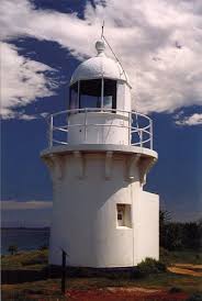
There are a number of Aboriginal mythology associated with the Fingal area, including that of Galiwus, a protective supernatural hairy man said to abide in a cave on Fingal Head and a mythological black dog which used to live in the caves on Fingal head, which have now been quarried away. The local Aboriginals are said to believe that when the caves were destroyed the dog became homeless and now roams the area.
Fingal Head is named Pooningbah, place of the echidna, referring to the shape of the basalt outcrop at the top of the headland.. At the northern end of Dreamtime Beach is a massacre site dating from the 1850s. There are shell middens and artefacts providing evidence of long Aboriginal occupation in the area1.

Minjungbal Aboriginal Cultural Centre
The Minjungbal Aboriginal Cultural Centre at South Tweed Heads is located
within the Tweed Heads historic site, which adjoins the Ukerebagh Nature
Reserve. Our aim is to preserve and protect the significant cultural
heritage of the area and to provide a facility for all people to explore and
enjoy the beauty of the native coastal bushland environment.
Tweed Heads
Twenty million years ago the Tweed area was a huge shield volcano stretching from Byron Bay to Nerang and far out to sea. Over eons of time the volcano became extinct and torrential rains washed away the lava, leaving a large volcanic plug, “Mt. Warning” and a caldera, the surrounding mountains, the McPherson and Nightcap Ranges and draining the new valley a river, ‘The Tweed’. Later the valley and its mountains were covered in lush, dense, sub tropical rain forests.

For thousands of years Aboriginal people lived in the Tweed area. They were the Nganduwal dialect tribal group. They lived as hunter-gatherers. Because food was very plentiful and consistently available their lifestyle was settled compared to many other tribal groups.
In 1770 Captain James Cook in HMS Endeavour, in his way up the eastern coast of Australia noted the reefs east of Cook Island and hove off the coast. The following morning he saw the sun on the mountain which he named Mt. Warning. The Aboriginal name for the mountain was Wollumbin or Rainmaker.
In 1823, John Oxley in the cutter “Mermaid”, on a voyage from Sydney in search of a place for convict secondary punishment, discovered the river which he named the Tweed after the river on the English / Scottish border.
Five years later, Captain Rous in the frigate “Rainbow”, journeyed in a ship’s whale boat up the river. In the process he recaptured nine escapees from the Moreton Bay Penal Settlement. Later a military outpost was set up on Point Danger to recapture run-aways. After a year the soldiers withdrew because of the hostilities with the aborigines caused by their infringement of tribal customs.
In 1844 the cedar getters arrived searching for timber with which to build the houses of Sydney and set up their camp near deep water at “Taranora” (aboriginal for “little river”) on Dry Dock Rd, South Tweed Heads. Schooners carried the logs south. Unfortunately many of them were wrecked on the river bar, which remained shallow and full of shoals until the retaining walls were built in the 1890′s when the channel in its turn started to continuously silt up. This problem has remained to this day.
Closely following the cedar getters came the boat builders. They built schooners, river boats and clinker built fishing and row boats to enable the settlers to get around the Tweed on the network of rivers before the development of roads, bridges and ferries were fully constructed in the 1930′s.
The Tweed was gradually opened up to selector farmers from 1866 to 1914. The first settlers tried many crops corn, arrowroot & opium, but finally settled on sugar in the late 1870′s as their staple crop. The sugar crop generated the need for sugar mills and much labour. Small mills at Bilambil, Tumbulgum & Cudgen were gradually replaced by two large ones the C.S.R. mill at Condong and the Robb Mill at Cudgen.
The latter was one of the few ‘plantation’ mills in Australia staffed largely by South Sea Island labour. It did not survive the introduction of the White Australia Policy. The Condong Mill is still the economic mainstay of the Valley.
The descendants of the Islanders remained in the Valley for many years as a major component of the sugar gangs.
The towns of the Valley grew slowly. Tweed Heads began to develop from 1870 onwards after a pilot station was opened there, and later the villages of Murwillumbah, Tumbulgum, Chinderah, Tyalgum & Uki became service centres. The railway reached Murwillumbah from Lismore in 1894 and the rail arrived at Tweed Heads from Brisbane in 1903. They were linked by river ferries until the 1930′s.
The primary sector diversified into dairying, banana growing and fishing at the beginning of the 1900′s and became major exporters of produce.
Point Danger

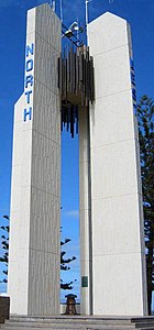
Point Danger was named by Captain James Cook in 1770, during his journey up the east coast of Australia, this headland served as a warning to mariners of this treacherous location
Kingscliff
Kingscliffs first name was Sutherland Point. It got this name when early settlers found a grave on the hill with the name Sutherland on it. Rich red fertile soil of Cudgen and the abundant sea-life on the coast of Kingscliff attracted the Tweed aboriginal clan of the Coodjingburra to settle in this area. They spoke the Bundjalung tongue and settled upon the coastal strip running from the Brunswick River to the Tweed River and then approximately fifteen kilometers inland to the now present site of Murwillumbah. The headland at Kingscliff was an important meeting place for this clan, with numerous middens near the beach proving testimony to the fine fishing and many corroborees
http://ausemade.com.au/nsw/destination/f/fingal-head/fingal-head-information.htm
http://tweedhistory.org.au/combined-tweed-river-historical-societies/tweed-history/
http://kingyhistory.celyoneill.com/aboriginals.html
